|
|

|
Trans
Canada Man- Sask |
|
"On every
side the snowy heads of mighty hills crowded round,
whilst, immediately behind us, a giant among
giants, and immeasurably supreme, rose Robson's
Peak." I am the
Yellowhead Valemount
and Tete Jaune Cache McBride Alpine
Adventure. The Robson Valley's breathtaking scenery
and unlimited
opportuni Prince
George Spirit of
the North. To wilderness adventurers, canoeists,
hikers and anglers, Prince George is a Mecca. A
quick glance at the Trans Canada Yellowhead Highway
map will show you that this is Northwest British
Columbia's crossroads of highways, railways, trails
and waterways. Located where the Fraser and Nechako
rivers meet, this former Hudson's Bay Company fort
offers easy access to numerous fishing lakes,
linked by a superb trail system. Explorers
Alexander Mackenzie and Simon Fraser, who traveled
these same arteries in the late 1700s, would be
awestruck by this large, modern city with over 120
parks, a major university and one of BC's busiest
airports. Looking
for a Theme Tour? Prince George offers Forestry
Tours, University Tours, Brewery Tours, Nature
Tours, Horse and Carriage Tours, Bison Farm Tours,
Horseback, Snowmobile and All Terrain Vehicle
Tours. Other options include tours of art
galleries, museums and heritage sites. Visitor
attractions abound, from Fort George Park, Fraser
Fort George Regional Museum Regional Museum, the
Heritage River Trail to the Prince George Railway
and Forest Industry Museum. A modern Provincial
Courthouse, Civic Center and Plaza are other
symbols of civic pride. The annual Prince George
Air Show in July and Salmon Valley Country Music
Festival are key events. The Prince George Symphony
Orchestra is well supported, and a thriving
community of musicians, writers and artisans live
in the area. Park
-Like Campus. The University of Northern BC is
perched atop Cranbrook Hill, its 750-acre campus
offering a panoramic view of the city, Forests for
the World Nature Park is located on the same
grounds, which stands to reason, with forestry
being the area's number one employer. In addition
to Canfor, largest Canadian-owned forest products
company, the area has 15 sawmills and 3 pulp mills.
Pacific Rim ties are a key to the future. Thanks to
the University, this position is strengthened by
faculty and student exchanges with universities in
Japan, Korea and New Zealand. Vanderhoof
and Fort St. James Hit the
Bullseye! The town of Vanderhoof is in the
geographical center of British Columbia, and was
named for Herbert Vanderhoof, who launched a 1908
government publicity campaign to attract settlers.
To many travellers Vanderhoof is their base for at
side trip to Fort St. James National Historic Site.
A connector (hwy. 27) takes you through ranch
country, by rivers lined with cottonwoods and
sparkling lakes. Explorer Simon Fraser founded Fort
St. James, in 1806. Here, BC's oldest continuously
inhabited community salutes its fur trading past,
as the past comes alive at an authentic Hudson's
Bay Trading Post, stocked with furs and trade
goods.. Fort
Fraser and Fraser Lake Fort Fraser
provides a full range of services and amenities.
Its annual Fall Fair, dating back to 1928, is one
of the province's oldest agricultural expositions.
The Hudson Bay Company fur trade brought explorer
Simon Fraser and his crew to nearby Stuart Lake and
from there to what 's now called Fraser Lake, near
the Nadleh Whut'en Indian Reserve. The Fraser Lake
HBC Post evolved into Fort Fraser, to become one of
the most important and strategic sites in New
Caledonia, British Columbia's original
name. Burns
Lake Burns Lake
is the main gateway to Tweedsmuir Provincial Park,
second largest park in British Columbia The
community of Burns Lake anchors Northern BC's "Lake
District," which is known to produce rainbow trout
up to 15 pounds, char (lake trout) up to 30 pounds,
and a variety of other game fish. Wildlife is
abundant throughout the Lake Country. In the early
1900's Burns lake was a major supplier of railroad
ties for the Grand Trunk Pacific Railway. Today's
economic pillars are logging, lumber production,
agriculture, ranching, and tourism. Houston Prepared to
catch the big ones? Perhaps the townsfolk at
Houston are trying to tell us something. "The
world's largest fly rod" on display here for the
world to see is a massive icon that's sixty feet
long and weighs eight hundred pounds. Plan to do
some fishing? Then stop at a local supply store and
get information on the best times and locations to
catch your limit. While there, be sure to stock up
on rods, bait and tackle. Regional
District of Bulkley-Nechako Wide Open
Spaces. This vast area, which includes Smithers,
Fort St. James, Vanderhoof, Burns Lake, Fraser
Lake, Granisle and Telkwa is a favourite of those
who love the great outdoors. It is a magnet to
thousands of visitors from Western Europe, who love
the unhurried, laid back way of life along this
scenic stretch of the Trans Canada Yellowhead
Highway. Smithers With Hudson
Bay Mountain filling the scene as a powerful
backdrop, little wonder the postcards we receive
from Smithers are so impressive. Now all we need
are postcards showing the record size fish that are
caught in these parts. A true Alpine community,
Smithers is the gateway to several of British
Columbia's most remote wilderness parks, and offers
a selection qualified guides on location. For a
Great Northwest Wildlife Safari, Babine Mountain
Provincial Park is ideal, being the home of grizzly
bear, deer, mountain goats and birds of every
colour and variety. Located in the heart of fertile
Bulkley Valley, Smithers has prospered during many
financial cycles. Speaking of other ups and downs,
Ski Smithers offers downhill skiers and snow
boarders a variety of options, and Bulkley's Valley
Nordic Centre provides a day lodge, back country
cabins and a first class system of well-groomed
trails. For the backcountry enthusiast there are
hundreds of km of terrain to play in for both skier
and , with cabins available through the Ski Club
and Snowmobile Association. Regional
District of Kitimat-Stikine A most
significant area in terms of native culture, the
Regional District of Kitimat-Stikine includes The
Hazeltons, Terrace and Kitimat, as well as Stewart,
a border community on the route to
Alaska. The
Hazeltons "Totem Pole
Capital of the World." Heartland of the Tsmishian,
Kitsumkalum and Gitskan, the Hazeltons are a Mecca
of First Nations Culture. A centuries old Gitksan
community was firmly established on this site when
settlers began arriving in the 1870s. The village's
name was Git-an-maks, "place where the people fish
by torch light." A huge attraction with most
tourists is K'san Tribal Village, with its carved
interior poles, artifacts and native dancers who
perform the ancient rituals. It was from
Hazelton that tribal elders and Royal Canadian
Mounted Police launched Vision Quest, a 1,200 km
canoe voyage along the Skeena and down the Pacific
Coast to Victoria. What a colourful spectacle they
made &endash; and for a worthy cause. British
Columbia's icon of the art world, Emily Carr, loved
the area with its sacred forests and rich heritage.
Hailed as one of Canada's great artists, Ms. Carr
loved the native people, and created many of her
priceless sketches in this area. Kitwanga North to
Alaska..At the village of Kitwancool, just north of
Kitwanga, visitors can marvel at the world's
largest standing totem pole,
"Hole-through-the-Ice," just one among many
historic totems in this region. From Kitwancool,
travellers can take the Cassiar-Stewart Highway
(37) that leads north to the Upper Liard in
Canada's Yukon. Terrace and
Kitimat How did
Terrace get its name? Geography played the major
role. As an example, the city's airport occupies a
flat gravel plateau or benchland, formed 10,000
years ago during the Ice Age's glacial retreat.
Here, layers of gravel deposited by rapidly
retreating glaciers and further eroded by the
action of rivers, formed an impressive series of
natural benches. It was like a giant Roman
amphitheatre. More recently, the Tseasx Lava Beds
and Nisga'a Memorial Lava Bed display a lunar
landscape left behind by a volcanic eruption. This
catastrophe happened over 250 years ago, destroying
two Nisga'a villages. These sites are important
tourist attractions. Native
culture is a huge attraction. With a row of totem
poles standing tall like sentries at the gate,
Terrace's House of Sim-oi-ghets is a showcase of
the Kitsumkalum people. Here visitors can buy
woodcarvings, rawhide moccasins, baskets, unique
jewelry and other souvenirs. There's a definite
Northwest flavour to the Terrace Farmers' Market,
and at Heritage Park, you can step right into the
horse and buggy era, with pioneer cabins, horse
stables, barns, and an early 1900s hotel. At Deep
Creek Fish Hatchery, visitors can follow the growth
of Chinook salmon, from egg to fry stage. Folks are
buzzing about the Skeena Sawmill Tours, so don a
hard-hat and see why BC is known as the world's
forestry capital. Perhaps a
local guide or seaplane operator at Kitimat can
arrange a safari to view the famous Kermode Bear,
seen only in Northern BC and its Coastal
Archipelago. The Terrace-Kitimat Gateway Airport is
only 5-minutes from Terrace and 20 minutes from
Kitimat. On Cannery
Row. Beyond Terrace, the Skeena, called "River of
Mists" by the Gitskan First Nations, widens into a
broad lake leading to an inlet of the Pacific at
Port Edwards. Fishing is the port's economic
engine, as visitors to its busy waterfront and
marina soon discover. The star attraction is the
ongoing restoration of an 1889 North Pacific
Cannery. Stretching northwest from Port Edward is
Chatham Sound, a noted recreation spot for boating
enthusiasts and fishermen. Other natural
attractions are Diana Lake for freshwater swimming,
Proudhomme Lake Provincial Park, Kloiya Bay and
Porpoise Harbour. Prince
Rupert "I first saw
Prince Rupert from the deck of The Princess Louise,
one of a fleet of Canadian Pacific passenger ship
that plied the Inside Passage to Alaska," a friend
relates. "The harbor was alive with canneries,
fishing fleets, coastal ferries, deep-sea ships,
and a huge grain elevator - it was
fascinating." Today,
Prince Rupert is buzzing with news of a great
revival, as the port gears up for a long awaited
cruiseship facility. Grand Trunk Pacific Railway
tycoon, Charles Hayes envisioned greatness for this
Northern port decades ago, but the plans and dreams
of Prince Rupert's biggest booster went down with
the Titanic in 1912. Today at Mount Hayes, named in
his honour, you can ride on the world's second
steepest gondola lift. BC Ferry trips are a popular
way to see the north coast, from Queen Charlotte
Islands to Port Hardy on Vancouver Island's
northern tip. Prince Rupert is the western terminus
of Via Rail Canada's Skeena Route, part of one of
the world's greatest transcontinental services. The
city's railroading past is honoured at the Kwinitsa
Station Railway Museum. The Oldfield
Creek Hatchery provides an insight into the
migration of coastal game fish. Speaking of a
pristine environment. Remote hikes take you deep
into the rain forest or to the rarified air, high
above tree line. There are dozens of other options
- on foot or by helicopter, float plane, horseback,
kayaking, cruising and sailing. Whale watching is a
huge draw and for a "safari type experience" the
North Coast and Alaska Panhandle provides access to
some of the best wildlife viewing in North
America. Native
Culture Abounds. The Museum of Northern BC has
totem pole carving on site, and at the same time,
displays 10,000-year-old works of art. Visitors can
enjoy an archeological boat tour or visit some of
the north coast villages of Port Edward, Lax
Kw'alaams (Port Simpson), Metlakatla, Oona River,
Gitkxaahla (Kitkatla), Gitga'ata (Hartley Bay),
Kitasoo (Klemtu) and Gingolx (Kincolith). Prince
Rupert's harbour is more active than ever, from
float plane sport fishing excursions to small craft
charters and cruises . Canada's
Galapagos. So you think you've conquered the
Yellowhead, right? Wrong! There's still a 6 hour
ferry trip to the Highway's far western terminus.
From Prince Rupert, your voyage to the "Misty
Islands" of Haida Gwaii (Queen Charlotte
Archipelago) is a salty experience - an authentic
taste of North Pacific life. Imagine making this
same crossing in a Haida canoe. Of more than
150 islands in the Haida Gwaii archipelago, only a
few larger ones are populated. Main communities are
Skidegate on Graham island, where the BC Ferries
dock, and the towns of Massett and Port Clements on
Massett Island. Queen Charlotte City is an active
community and Sandspit has a full service airport
operated by Transport Canada. Anthony Island's
abandoned village, Ninstints, is a UNESCO World
Heritage site. There are over 500 archeological and
historical Haida sites in the area. |
|||||
 Heading
westward through the "Yellowhead Pass," with the
gentlest grades of all great Canadian mountain
passes, I cross another historic border entering
beautiful British Columbia, Canada's most westerly
province. Near Tete Jaune Cache, in the shadow of
Mount Robson, tallest peak in the Canadian Rockies,
I give motorists two pleasant options. One of my
long arms points northwest, as I follow the Fraser
River to Prince George, and the Skeena River to
Prince Rupert. My other arm points south where I
follow the North Thompson River to Kamloops, then
carry on to Merritt and Hope, gateway to the Fraser
Valley and Port of Vancouver.
Heading
westward through the "Yellowhead Pass," with the
gentlest grades of all great Canadian mountain
passes, I cross another historic border entering
beautiful British Columbia, Canada's most westerly
province. Near Tete Jaune Cache, in the shadow of
Mount Robson, tallest peak in the Canadian Rockies,
I give motorists two pleasant options. One of my
long arms points northwest, as I follow the Fraser
River to Prince George, and the Skeena River to
Prince Rupert. My other arm points south where I
follow the North Thompson River to Kamloops, then
carry on to Merritt and Hope, gateway to the Fraser
Valley and Port of Vancouver.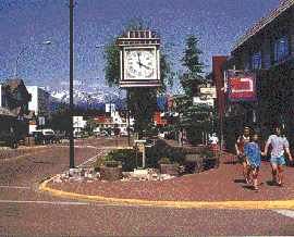 ties
for heli-skiing, fishing, back packing and white
water sport, assures McBride a promising future in
eco and adventure tourism. Birdwatchers take note;
at nearby Horseshoe Lake, over 170 species of birds
and waterfowl have been identified. Before leaving,
make sure your gas tank is full to the brim;
McBride to Prince George is one of the longest
stretches on the entire Trans Canada Yellowhead
Highway without a community of any size. Check your
supplies too -- the highway follows the Fraser
River, which offers ample opportunities for
fishing, hiking and roadside camping. McBride's
economy was built on railroad activity and
forestry
ties
for heli-skiing, fishing, back packing and white
water sport, assures McBride a promising future in
eco and adventure tourism. Birdwatchers take note;
at nearby Horseshoe Lake, over 170 species of birds
and waterfowl have been identified. Before leaving,
make sure your gas tank is full to the brim;
McBride to Prince George is one of the longest
stretches on the entire Trans Canada Yellowhead
Highway without a community of any size. Check your
supplies too -- the highway follows the Fraser
River, which offers ample opportunities for
fishing, hiking and roadside camping. McBride's
economy was built on railroad activity and
forestry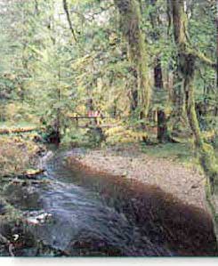 Haida
Gwaii - Queen Charlotte Archipelago
Haida
Gwaii - Queen Charlotte Archipelago