|
Airport
Sandspit,
Gateway to Canada's Galapagos, Haida Gwaii,
Queen Charlotte Islands:
by
Jerry W. Bird
 When
Sandspit's Airport Manager phoned for some
additional cartons of Air Highway Traveler Magazine
and Supermap, it was a signal that things were
cooking up north, and not just Sockeye salmon on
the propane grill. Our media marketing plan was "on
target" in an important market segment. Why? The
clientele at Sandspit Airport in the Queen
Charlotte Islands is not made up of your ordinary
garden variety passengers. These people are first
and foremost outdoor sportsmen from the USA, the
Calgary Petroleum Club and Vancouver's Howe Street,
who come to the North Pacific to catch big fish.
They're not shy about paying top price for their
fun. The charter boats, float planes, helicopters -
whatever it takes. This is the kind of good news we
love to pass on to our advertisers, without whom we
could not produce the magazine in the first place.
British Columbia. When
Sandspit's Airport Manager phoned for some
additional cartons of Air Highway Traveler Magazine
and Supermap, it was a signal that things were
cooking up north, and not just Sockeye salmon on
the propane grill. Our media marketing plan was "on
target" in an important market segment. Why? The
clientele at Sandspit Airport in the Queen
Charlotte Islands is not made up of your ordinary
garden variety passengers. These people are first
and foremost outdoor sportsmen from the USA, the
Calgary Petroleum Club and Vancouver's Howe Street,
who come to the North Pacific to catch big fish.
They're not shy about paying top price for their
fun. The charter boats, float planes, helicopters -
whatever it takes. This is the kind of good news we
love to pass on to our advertisers, without whom we
could not produce the magazine in the first place.
British Columbia.
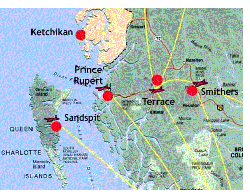
We
had already experienced a good reaction at Prince
Rupert, so this was the icing on the cake. It was
part of a circulation plan that involved over 30
locations, primarily airports, corporate jet bases,
seaplane bases and heliports throughoutLocated off
BC's northwest coast, this archipelago, once
considered remote, is now easily accessible by air
to Sandspit on Moresby Island.
 You
can also fly to Masset on Graham, Island, or take
BC Ferries from Prince Rupert to Skidegate. Made up
of the peaks of a submerged volcanic ridge of the
continental shelf, the "Misty Islands'. live up to
their nickname; local mountains and shores are
often shrouded in a mysterious and evocative mist.
The rugged and rocky west coast of the island faces
the ocean, while the east coast has many broad
sandy beaches. Named by British Capt. George Dixon
, in 1787, one of the first European explorers of
the region, after the wife of George III, the Queen
Charlottes contain some of the best examples of
temperate rain forests in the world. You
can also fly to Masset on Graham, Island, or take
BC Ferries from Prince Rupert to Skidegate. Made up
of the peaks of a submerged volcanic ridge of the
continental shelf, the "Misty Islands'. live up to
their nickname; local mountains and shores are
often shrouded in a mysterious and evocative mist.
The rugged and rocky west coast of the island faces
the ocean, while the east coast has many broad
sandy beaches. Named by British Capt. George Dixon
, in 1787, one of the first European explorers of
the region, after the wife of George III, the Queen
Charlottes contain some of the best examples of
temperate rain forests in the world.
 For
10,000 year these Islands have been the traditional
home of the Haida Indians, skilled carvers and
mariners, who paddled their dugout canoes as far as
San Francisco. See examples of their art and
culture, including beautifully carved totem poles
at Haida Gwaii Museum near Skidegate, Ninstints, a
United Nations World Heritage Site, is the best
preserved totem village in the world. There are
over 500 archeological and historical Haida
sites. For
10,000 year these Islands have been the traditional
home of the Haida Indians, skilled carvers and
mariners, who paddled their dugout canoes as far as
San Francisco. See examples of their art and
culture, including beautifully carved totem poles
at Haida Gwaii Museum near Skidegate, Ninstints, a
United Nations World Heritage Site, is the best
preserved totem village in the world. There are
over 500 archeological and historical Haida
sites.
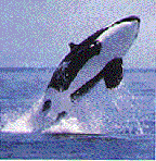
Canada's
Galapagos: The fog-shrouded waters of Haida
Gwaii, aboriginal name for the Queen Charlotte
Archipelago, teem with sea life, including salmon,
herring, halibut, rockfish, mussels, crab,
starfish, sea urchin and octopus. Armadas of Gray,
Humpback and Killer Whales skip along the surface,
and sea-birds abound. Cape St. James is home to
large colony of sea lions. Isolation from the
mainland has given rise to a unique subspecies of
wildlife. Adventurers can head out from Queen
Charlotte City or Sandspit to explore this
far-flung archipelago, or explore the endless sans
dunes of Graham Island's Naikoon Provincial Park.
The southern end of Moresby Island is part of Gwaii
Haanas National Park Reserve and Haida Heritage
Site. Reservations are required to visit the area,
which is accessible only by boat or plane. The many
recreational opportunities include kayaking,
sailing, scuba diving and boat charters. Many
licensed commercial operators offer various tour
packages including visits to ancient Haida villages
such as Ninstints. Many fishing charters operate
out of these local communities. It's an ocean
salmon paradise, with floating resorts and fly-in
lodges. The eastern shores of the islands facing
the Inside Passage have many broad sandy
beaches.
An
exciting variety of activities
• Explore ancient Haida cultural sites, such
as Gwaii Haanas National Park Reserve Site
• View natural history, old-growth rain
forests and abundant sea life, birds and
mammals.
•
Hike into sub-alpine areas, remote lakes and
spectacular stream settings.
•
Be a "beachcomber" and stroll the many islands in
the archipelago's southern reaches
•
Relax in the natural hot springs.
• Explore
historic mining sites and cannery
operations'
•
Enjoy canoeing, kayaking and snorkeling in coastal
waters
•
Discover dozens of excellent photo
opportunities.
•
Enjoy fishing at the Queen Charlottes floating
lodges. Few places in the world offer a better
chance of boating a trophy "tyee" a chinook or king
salmon of at least 30 lbs. Halibut fishing is also
exceptional; most halibut weigh in at 15 to 35 lbs,
but they can also be huge - some at over 300
lbs.
For
leasing, business opportunities, flight information
and airport services, contact Sandspit Airport
(604) 637-5313, Fax (604) 637-5661
Letter from a reader
...
I was browsing the internet
looking for an aerial view of the airfield at
Sandspit and came across your email address.
My hobby, along with a number of other chaps is
flying Microsoft Flight Simulator 2004 (or FS9 as
it is also called). If you are not familiar
with it, it does provide a remarkable level of
virtual reality. This afternoon, along with
four other chaps we were flying a simulated SAR
mission out of Sandspit. One of the chaps is
from the UK and the others are Americans while I am
Canadian. I actually flew out of Sandspit in
September 1954 with a crew doing aerial
photography. The airport itself was our
primary area. I was the photo/navigator and
officer in charge of the operation.
We, and the aircraft (C-47) were
based in Rivers Manitoba. As the only photo
qualified navigator on the base and since we had a
photo equipped aircraft, RCAF HQ's would send us
jobs to fly that were of lesser priority than the
ones 408 Photo Squadron was involved with. At
the time I was a photo interpretion instructor at
Rivers and was also the base photo officer.
It was a great situation. Between
instructional duties with courses I had my filing
drawer full of photo jobs to be done and an
aircraft waiting. The Sandspit job was one of
those. I had developed a techinique whereby I
could pretty well guarantee framing the entire
airport property in one frame.
So I was wondering if by rare
chance you might have a copy of the overhead
vertical photograph we took back in those
days. Since then, according to what I have
seen on the internet, Sandspit has grown many
fold. If by chance you do have an aerial
vertical photo I wonder if it would be possible to
scan it and send me a copy. My
UK "Flight Sim" friend is skilled at
embellishing the stock scenery in the simulator and
he has already added some scenery to Sandspit using
his own imagination. If he had an actual
aerial photograph to work from it would be even
better. 1954 was a long time ago, 50 years
ago to be more precise. I am now 76 and have
only a vague recollection about where things were
around the airport.
I apologize if this seems a
frivolous request, but it was worth a
try.
Sincerely, Alex
Saunders
[Top
of page]
http://www.edmontonairports.com/
|